Previous image
Maine V3
Next image
Zoom image

Maine V3

The entire state of Maine V3

  • $11.97
Market price: $29.95, you save $17.98
  • 60% less
Qty:  
  • Delivery info

    Instant Download. Be flying within the hour depending upon the speed of your connection. Optional DVD or flash drive media can be selected from the delivery options pulldown menu above.

  • Payment methods

    creditcards_1.jpg

  • SKU
    DL-MSEV3-ME

The New MegaSceneryEarth Maine V3 featuring unsurpassed image sharpness, scenery color and clarity, 
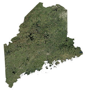
improved scenery features with accurate additional water bodies and topographical data and the latest aerial imagery available taken in 2015.

Fly the entire state - BORDER to BORDER - of Maine in photoreal detail.

Maine is 35,385 square miles in size and has 144 airports. You'll see everything that you see in Maine in real life in the scenery.

Maine is a large state with so much area to fly. The screenshots below don't come close to even scratching the surface of how much area there is to fly. Discover it all for yourself when you purchase this state.

As an added bonus, we now provide all the VFR and IFR charts in digital PDF format to enable you to get the most out of your scenery. This includes TACs and Sectionals, IFR enroute charts and 161 page book of Instrument Approach plates, Airport Diagrams, SIDs and STARs. The charts are downloadable along with your scenery files.

Some of the cities and landmarks you'll get to enjoy as you explore Maine include:

Cities: Portland, Lewiston, Bangor, Auburn, Biddeford, Sanford, August, Brunswick

Lakes & Waterbodies: Moosehead, Sebago, Chamberlain, Churchill. Eagle, Chesuncook, West Grand Lake, Atlantic Ocean Coastline.

Mountains & Hills: Mt Katahdin (5,246 ft & end of the Appalachian Trail), Baxter Peak, South Peak, Chimney Peak, Sugarloaf Mountain and a total of 50 peaks above 3,500 ft.

State Parks & National Forests: White Mountains National Forest, Baxter State Park, Allagash, Acadia, Debsconeag.

Major Rivers: Androscoggin, Kennebee, Penobscot, St. John, Saco.

Discover the rest of it all for yourself! There's a LOT to see!

This is a download edition with the option to order a DVD disk set (9 discs).

When you order the DVD disk set you will still receive download links. If you do not wish to download, simply wait for your DVD's to arrive in the mail.

 THIS TITLE COMES WITH A FULL SET OF FAA AERONAUTICAL CHARTS FOR Maine IN PDF FORMAT.

Here's what you get (download links for charts will be given to you with your product download): 

SECTIONAL CHARTS: Halifax & Montreal

LOW ALTITUDE IFR CHARTS: ELUS-31/ELUS-32

HIGH ALTITUDE IFR CHARTS: EHUS-11/EHUS-12

APPROACH CHARTS & AIRPORT DIAGRAMS:  A 161 PAGE PDF BOOKLET

  • AREA SIZE (Sq. Miles)
    35,385
  • DOWNLOAD (Mb)
    24,633
  • NOTES 2:
    You will be sent a license number to activate. if you do not receive in your e-mail, please login to your account and you will find your license number attached to your order.
  • DATE OF AERIAL IMAGERY
    2015
  • COMPATIBILITY
    FSX/FSX:SE/P3D V1, V2, V3, V4, V5
  • DOWNLOAD TIME (1 Gb, 300, 100, 50 Mbps)
    5 Mins, 18 Mins, 55 Mins, 110 Mins
  • VERSION
    3.6.15

INSTANT DOWNLOAD
All titles are available by instant download as the primary delivery method however you can also optionally order your titles to be delivered on DVD or USB Flash Drive. There are no postage charges for DVDs or flash drives. The price of the additional media is all inclusive and covers the costs of the media, replication time, packaging and postage.

DVD
Most titles, due to size, require multiple DVD's and we charge $2 per DVD which includes mastering and postage charge. All DVD's are professionally produced along with automatic installers so all you need to do is to insert the DVD into your drive and follow the prompts for installation. USA customers please allow up to 10 days for delivery (typically 4 to 5 days). Outside the USA please allow up to 21 days (typically 7 to 12 days).

USB Flash Drive
We charge for the cost of the flash drive (from 8 Gb up to 128 Gb depending upon the size of the area) plus a small fee for the process of placing your scenery onto the flash drive. Your scenery will have an auto installer on the flash drive so all you need to do is plug in your flash drive and select the autorun option to commence the installation of your scenery. USA customers please allow up to 10 days for delivery (typically 4 to 5 days). Outside the USA please allow up to 21 days. (typically 7 to 12 days).


Also...
If you order optional DVDs or USB Flash Drive you will also always receive download links. You do not need to contact our office if you ordered DVDs or flash drive and received download links. If your final invoice/order shows that you ordered DVDs or flash drive then your requested media will arrive in the mail within the above mentioned time windows based upon your location. You will receive an e-mail when your media ship along with a tracking number. Generally DVDs and Flash drives are sent via First Class Mail or Priority Mail with in the USA and First Class International Air Mail outside the USA.

We accept the following payment methods:

Customers who bought this product also bought
Drop items here to shop
Product has been added to your cart
  • Drag and drop me to the cart
    • $0.00
  • Drag and drop me to the cart
    • $4.97
    • 50% less
  • Drag and drop me to the cart
    • $9.97
    • 50% less
  • Drag and drop me to the cart
    • $9.97
    • 50% less
  • Drag and drop me to the cart
    • $9.97
    • 50% less
Consider These Neighboring States For a Larger Continuous Area To Fly
  • Drag and drop me to the cart
    • $9.97
    • 50% less