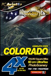
The New MegaSceneryEarth Colorado Version 3 - 2017 features unsurpassed image sharpness, scenery color 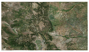 and clarity, improved scenery features with accurate additional water bodies and topographical data and the latest completely-up-to-date aerial imagery available taken in 2017.
Border To Border
Fly the entire state - BORDER to BORDER - of Colorado in photoreal detail in 1 meter per pixel resolution throughout..
Colorado is over 104,093 square miles in size and has 272 airports. You'll see everything that you see in Colorado in real life in the scenery.
Colorado is a visually spectacular and fun place to fly with Rocky Mountain terrain with towering mountain peaks above 14,000 feet. Average elevation of Colorado is 6,800 feet, higher than any other state. This kind of terrain is where MegaSceneryEarth V3's high res graphics really shine. You'll be truly stunned by the scenery of Colorado.
 Features New AtmosCLEAR™ Image Clarity
Colorado imagery is processed using our proprietary AtmosCLEAR™ image processing. AtmosCLEAR™ is a post production image processing technique that simulates the image being photographed in a vacuum to eliminate all atmospheric haze and artifact. It's clear of atmosphere. The result is a crystal clear mathematically optimally contrasted image.
Fly Colorado Both Day and Night
Colorado blends seamlessly with FSX and Prepar3D night scenery so that dawn and dusk feature a blend of aerial imagery and night lighting while the scenery transitions to full day or full night where all default FSX night scenery displays.
Complete Colorado Hydrography
Colorado also features Flight Simulator water effects on all lakes, ponds and reservoirs greater than 3 acres from the national hydrographic database. If the water body is greater than 5 sq km, then its shorelines are hand etched pixel by pixel for highly accurate shorelines. Wide rivers also have hand etched shorelines and banks. The raw photographic water body is left untouched with the result being an authentic variety of different water colors that highlight specific properties e.g. mineral lakes whose color is maintained. Where possible water surface artifact is removed from the image. For users who like to see the water bodies as they are, then simply turn off the simulator water effects and you will see the native aerial images of the water bodies as you fly. Specific characteristics of narrower rivers require that we do not apply water effect to narrow rivers and creeks for a better scenery result.
All The Charts You Need To Navigate Colorado
As an added bonus, we now provide all the VFR and IFR charts in digital PDF format to enable you to get the most out of your scenery. This includes 3 Sectionals, 2 Terminal Area Charts, 5 IFR enroute charts, and a 477 page book of Instrument Approach plates, Airport Diagrams, SIDs and STARs, and an Airport Facility Directory. The charts are downloadable along with your scenery files.
Some of the cities and landmarks you'll get to enjoy as you explore Colorado include:
Cities: Denver, Colorado Springs, Aurora, Lakewood, Fort Collins, Arvada, Boulder
Lakes & Water Bodies: Grand Lake, Blue Mesa Reservoir, John Martin Reservoir
Mountains & Hills: Mount Elbert (14,426 ft), Mount Harvard, Mount Massive, La Plata Peak, Blanca Peak and a total of 50 other peaks and mountains above 14,000 feet. Mean state elevation 6,800 ft.
State Parks & National Forests: Arapaho National Forest, Comanche National Grassland, Grand Mesa National Forest, Gunnison National Forest, Pawnee National Grassland, Pike National Forest, Rio Grande National Forest, Roosevelt National Forest, Routt National Forest, San Isabel National Forest, San Juan National Forest, Uncompahgre National Forest, White River National Forest
Major Rivers: Colorado River, Rio Grande, Arkansas River, South Platte River
Other Highlights: Aspen
Discover the rest of it all for yourself! There's a LOT to see!
This is a download edition with the option to order a DVD disk set (12 discs) or 64 Gb USB flash drive..
When you order the DVD disk set or flash drive you will still receive download links. If you do not wish to download, simply wait for your media to arrive in the mail.
THIS TITLE COMES WITH A FULL SET OF FAA AERONAUTICAL CHARTS FOR Colorado IN PDF FORMAT.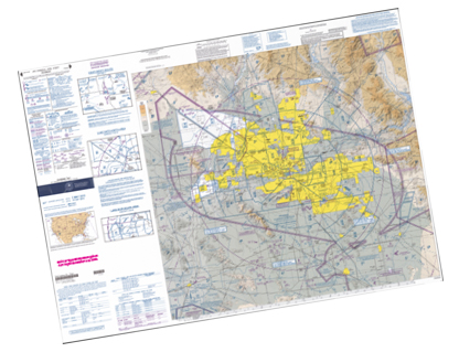
Here's what you get (download links for charts will be given to you with your product download):
SECTIONAL CHARTS: Cheyenne, Denver, Wichita
TERMINAL AREA CHART: Denver, Colorado Springs
LOW ALTITUDE IFR CHARTS: ELUS-07/ELUS-08, ELUS-09/ELUS-10, ELUS-15/ELUS-16
HIGH ALTITUDE IFR CHARTS: EHUS-03/EHUS-04, EHUS-05/EHUS-06
AIRPORT FACILITY DIRECTORY: A FULLY INDEXED 46 PAGE PDF BOOKLET
APPROACH CHARTS & AIRPORT DIAGRAMS: A FULLY INDEXED 477 PAGE PDF BOOKLET